On a beautiful still and sunny day, 22nd February, 2015, we visited Point Wells to observe the effects of the king tide i.e. a high tide of 3.7m. [Read more…]
Whangateau Harbour Important Nursery for Parore
Hundreds of young parore, mostly about a year old, were hovering under the Omaha Causeway Bridge this morning. They were taking advantage of a calm spot in an eddy as the tide started racing out.

Hundreds of young parore shelter under the Omaha Causeway Bridge as the tide begins to drop. The western row of bridge support columns can be seen in the background.
According to Mark Morrison from NIWA, who did his MSc thesis on parore, the Whangateau Harbour produces all the parore for the coast from Pakiri to Kawau Bay. There are two sandstone reefs in the Harbour which serve as nursery areas for parore. One is about 200 metres south of the Causeway bridge and can be seen from the bridge when the tide is low. The other is on the Point Wells side of Horseshoe Island and is a popular snorkeling area alongside the channel. Masses of necklace weed grow on the reefs providing a sheltered habitat for the young parore.
In late January hundreds of recently settled parore only 20mm long shelter amongst the branches of mangrove trees when the tide is in. Here they continue to pick plankton organisms from the water, at the same time as beginning their herbivorous life by nipping at micro-algae growing on the mangrove branches.

Juvenile parore only 20mm long sheltering among the branches of large mangrove trees in the southern part of Whangateau Harbour. The barnacles on the branches at left give you an idea of the scale.
The tiny parore settle from their planktonic larval stage at about 12mm long and can be found schooling in estuaries and the lower parts of creeks when they are hardly recognizable just developing their stripes.
A Peek Into the Future for Point Wells
On Saturday, 11th October three HarbourCare members went down to the seaside of the new subdivision at Point Wells. It was 10am, just before the peak of a spring tide. It was a pleasant spring day with a light Southerly breeze and a slight chop on the water. We were very impressed by the volume of seawater covering the area the Council has designated as Esplanade Reserve”.
Development at Point Wells
This report documents the reasons for my concerns about the development at Point Wells.
Early in this century the RDC proceeded through a detailed consultation process to develop Point Wells and Omaha Flats resulting in the “Point Wells and Omaha Flats Sustainable Development Plan.” The Point Wells community had approved the final draft of the plan and fully supported it when it was ratified by Council. At the Councillor hearing the owners of 228 Point Wells Road employed Terra Nova Planning (Shane Hartley) to present a plan for development of their site which conformed to the wishes of the community and included a significantly wide reserve with path along the foreshore with appropriate public access. This was fully supported by the Whangateau HarbourCare Group (Inc) in their submission. [Read more…]
Storm of 17th April Floods Popular Harbourside Reserve
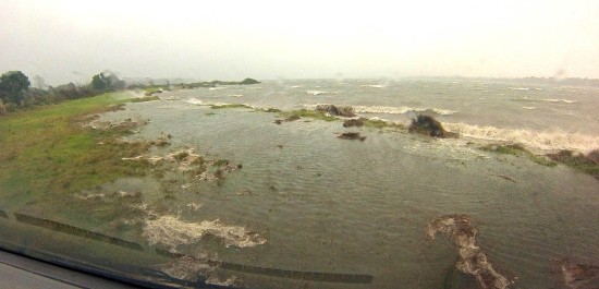
The high tide and storm surge on the tail of cyclone Ita created a bit of havoc around the Whangateau Harbour. With sea-level set to rise at an accelerating rate, this storm should be a warning about the wisdom (or lack of) of building new housing close to sea-level along the Point Wells harbour shore, as outlined in a recent posting on this site.
Planning for Rising Sea Levels – Not!

A feature of this storm was the presence on the high tide line of large volumes of peat in the Esplanade Reserve.
The Structure Plan for Point Wells was a long time in the consultation process but ultimately produced a logical plan approved by the community in the settlement. This plan avoided increased development close to the coast and most importantly provided good pedestrian access to the water with a broad strip of protective, grassed reserve between the sea and proposed development.


